How Hydrology Shapes the Design, and Cost, of High-Speed Rail
Why water is the hidden factor that should be examined before making any route decisions.
Hydrology, the behaviour of water in and on the ground, is one of the most consequential and least publicly discussed constraints on high-speed rail design. HSR slab track must maintain alignment to within 15 mm of post-construction settlement, two-thirds of an inch, over its entire operational lifetime. Water is the primary agent of settlement. Every HSR design decision ultimately flows from the need to keep water away from the track foundation. This has direct and significant implications for the ALTO route choice in Eastern Ontario.
This research note explains why water, beneath the ground, in the soil, flowing across the landscape, is the single most important engineering factor in choosing a high-speed rail route. It is written for citizens participating in the ALTO public consultation who want to understand why the choice between the northern and southern corridors is not simply “rock vs. farmland” but involves fundamental differences in long-term cost and engineering risk.
The analysis draws on peer-reviewed research from high-speed rail projects worldwide [1, 2, 3, 4, 5], regulatory precedent from California’s HSR environmental assessment [6], and the UK’s High Speed 1 experience [7]. It applies these findings to the specific geological and hydrological conditions of Eastern Ontario.
The tolerance problem: why high-speed rail and water don’t mix
The fundamental reason hydrology matters so much more for high-speed rail than for conventional rail, or roads, is the extraordinary precision required of the track structure. High-speed trains operating at 300 km/h impose forces on the track that are orders of magnitude greater than those of slower trains. A millimetre of misalignment that would be imperceptible at 100 km/h can cause dangerous oscillations at 300 km/h.
Imagine a highway with a tiny dip that you’d never notice at 60 km/h. At 300 km/h, that same dip could throw a train off course. That’s why the ground beneath high-speed rail track must be almost perfectly stable, forever.
For ballastless (slab) track, the standard for modern high-speed rail, post-construction settlement of the ground beneath the track must be kept below 15 mm. That is approximately two-thirds of an inch, over the entire operational lifetime of the line. This is not a construction quality standard; it is a permanent operational requirement. And crucially, once slab track settles, it cannot be simply fixed by routine maintenance the way traditional ballasted track can be tamped back into alignment [1].
Water is the primary agent that causes settlement. Saturated or repeatedly wetted soils compress under load, lose bearing capacity, and shift in ways that dry, stable ground does not. Canada’s seasonal freeze-thaw cycle adds further complexity: water that infiltrates the ground beneath the track and then freezes causes frost heave, upward displacement, followed by settlement on thawing [2]. Even small gradients of movement across the track translate directly into safety and comfort problems at operating speed.
Mud pumping: what happens when slab track gets wet
Mud pumping is a specific and serious failure mode that affects high-speed slab track under wet conditions, and it has no real equivalent in conventional railway engineering. Understanding it is essential to understanding why drainage design is so critical, and so expensive [3].
When rainfall, even moderate, persistent rainfall, infiltrates the narrow gaps between the concrete track slab and the ground beneath it, something damaging occurs every time a train passes at high speed. The vibration literally pumps fine soil particles upward through those gaps. Over time, this creates voids beneath the slab: the track is supported in some places and unsupported in others, creating exactly the kind of uneven settlement the track cannot tolerate [3].
Research has confirmed that mud pumping occurs only when structural gaps, standing water, and the cyclic vibration of passing trains coincide, which means it is both predictable and preventable, but only if drainage is designed correctly from the outset.
Research on China’s extensive high-speed rail network has shown that areas with extreme rainfall events are typically designed with better drainage specifically because the risk is obvious. It is chronic, moderate rainfall, particularly combined with imperfect drainage, that causes progressive failure over time [2]. In a climate like Eastern Ontario’s, with relatively consistent annual precipitation spread across many months and a significant freeze-thaw cycle, this is a material long-term operational concern.
The engineering response to mud pumping is a multi-layered drainage system. The ground beneath the concrete must be effectively sealed with asphalt concrete to prevent water seeping up from below. Rainwater that enters from the sides must be rapidly evacuated through specially designed permeable shoulders and blind ditches. Research has shown that an optimized drainage system reduces standing water time by up to 90%, but the engineering requirements are demanding and must be calibrated to regional rainfall conditions [3].
Design Consequence
Mud pumping means that drainage design cannot be treated as a secondary consideration during route planning. Sites with high water tables, seasonally wet soils, or frequent stream crossings require substantially more complex and expensive drainage engineering. This cost is not just in construction; it persists through the entire operational lifetime of the line as monitoring, inspection, and potential remediation work [1, 3].
The ground beneath the track: water, soil, and settlement
The type of soil or rock beneath the track determines how water behaves, how settlement occurs, and what engineering is required. HSR projects must address three distinct water-related challenges [1, 4, 5].
A high water table creates upward pressure against the track foundation and reduces the ground’s ability to support weight by saturating soils. In frost-susceptible soils, it also creates seasonal freeze-thaw risk. Research on China’s HSR network found that climatic factors, particularly the interaction between annual rainfall and freezing days, predominantly influence frost damage in HSR foundations, underscoring that this is very much a Canadian climate concern [2]. Areas with seasonally high water tables require either deep drainage installation or frost-resistant fill materials, both of which add significant cost.
Soft soils have high compressibility and low permeability. Under the sustained weight of an embankment and the vibration of passing trains, they compress slowly over years and decades. Post-construction settlement in soft soils is extremely difficult to control, seriously threatening the safe operation of high-speed trains [4]. Treatment options include pre-loading the ground before construction, installing vertical drain systems, or pile foundations carrying the track to stable rock below. All are expensive, and all require extensive investigation to design correctly.
Clays that swell when wetted and shrink when dried create cyclical heave and settlement that is particularly damaging to slab track. High-speed railways operating above 200 km/h have very small settlement tolerance, making it extremely difficult to meet requirements in zones of expansive soil [5]. Southern Ontario’s clay-till soils require careful assessment wherever a route passes through clay-rich terrain.
Floodplains, wetlands, and stream crossings
Every time a high-speed rail line crosses a watercourse, floodplain, or wetland, it triggers a cascade of engineering requirements and regulatory obligations. These are among the most technically complex and cost-intensive elements of HSR design [6].
The Engineering Requirements
HSR crossings of floodplains and rivers must be designed so the railway does not act as a dam that backs water up on the upstream side. Canadian regulations require that bridges provide flow conveyance and connectivity, meaning bridges designed to pass the 100-year flood event without overtopping, with sufficient span and clearance for flood flows plus debris and ice [6].
Unlike a road crossing, where a culvert is often adequate, HSR cannot use culverts for any significant watercourse, because culverts create grade changes and local ponding that would destabilize the track foundation. Bridges are required. Each crossing requires a full hydrological assessment of the watershed and flood frequency, a hydraulic model, scour analysis, and regulatory review by Conservation Authorities, Transport Canada, and Fisheries and Oceans Canada [6].
The Piled Viaduct Solution for Wetlands
Where ground conditions are so poor that conventional preparation cannot achieve the required settlement tolerances, the solution is to take the track off the ground entirely on a piled viaduct, essentially a bridge through the wetland. This approach was used on High Speed 1 in the United Kingdom to traverse the highly unstable East Thames marshes [7]. It is technically reliable but enormously expensive, converting what would otherwise be an earthworks problem into a structural one.
Secondary Effects: The Railway as a Dam
A high-speed rail embankment running across the landscape acts as a drainage divide. On the upslope side, it intercepts natural drainage. On the downslope side, drainage patterns are altered. In areas with clay-till soils, subsurface water connectivity between wetlands is common, meaning an embankment disrupting groundwater flow in one location can affect wetlands and farmland drainage hundreds of metres away [9].
Why slab track makes all of this non-negotiable
Modern high-speed rail is almost universally built with ballastless slab track rather than traditional ballasted track. The choice is driven partly by water, and it makes getting the drainage right absolutely critical [8].
At speeds approaching 300 km/h, aerodynamic forces lift ballast particles from the track bed and project them at high velocity, the “ballast flight” problem. Ballasted track also requires frequent tamping maintenance. Slab track solves these problems: it offers highly consistent track geometry, a service life of up to 100 years, reduced maintenance, and elimination of the ballast flight problem [8].
But the critical vulnerability is the flip side of this strength: if slab track settlement does occur, there are no simple solutions. Unlike ballasted track, where settlement is corrected by adding ballast and tamping, slab track settlement requires grouting beneath the slab, underpinning, or in serious cases complete removal and reconstruction. This is expensive, disruptive, and cannot be performed quickly. The slab track commitment therefore means that getting the ground right at the outset is not merely desirable; it is functionally mandatory. And getting the ground right means getting the drainage right [1, 8].
What this means for ALTO’s route choices in Eastern Ontario
The ALTO northern vs. southern corridor comparison is, at its core, a trade-off between two fundamentally different water problems. The public framing has emphasised rock (northern) vs. agricultural land (southern). The hydrological reality is more nuanced, and consequential [11].
Wetlands Analysis: Geology Controls Water
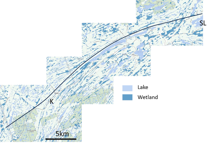
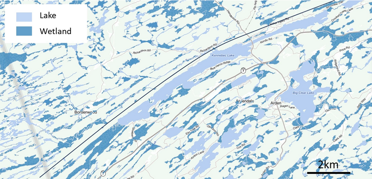
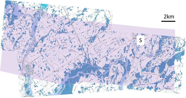
A perception exists that the northern route on the Canadian Shield is poorly drained with many wetlands to negotiate. However, just as the geology controls the shape of the land, it also controls the distribution and shape of the wetlands. Within the Mazinaw geological terrane, the wetlands, like the lakes, tend to be elongated in the same direction as the geological structure, which is parallel with the railway alignment.
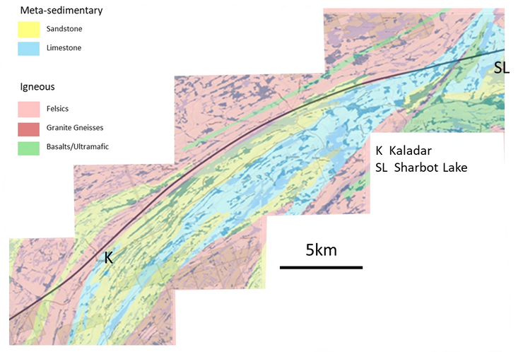
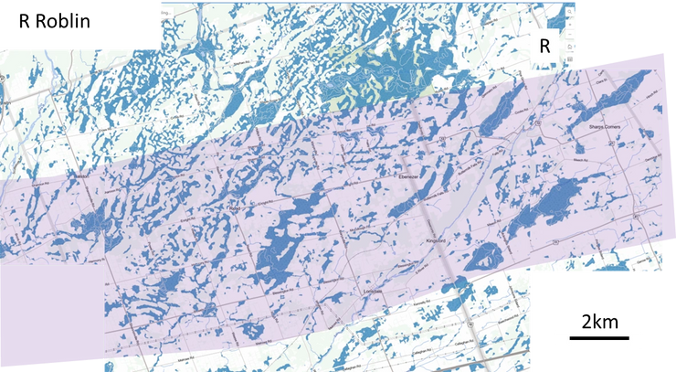
At first glance the southern corridor may seem more attractive since there are fewer wetlands owing to agricultural drainage conducted over the last 200 years. However, the remaining wetland areas are actually more abundant and considerably more disorganized in distribution and form.
Watershed Position: Headwater vs. Downstream
The two routes occupy very different positions in the watershed. The northern route sits near the headwaters of the Trent and Rideau River watersheds, small streams with small catchment areas, running parallel to the alignment.
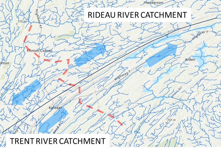
The southern corridor, by contrast, sits in a downstream watershed position where the Cataraqui, Napanee, Salmon, Moira, and Trent rivers drain south into Lake Ontario. These watercourses experience prolonged spring runoff periods, and ice damming with associated flooding is common. On agricultural land, tile drainage systems direct water rapidly into moderate-sized streams, meaning the landscape’s natural ability to absorb water has been disrupted.
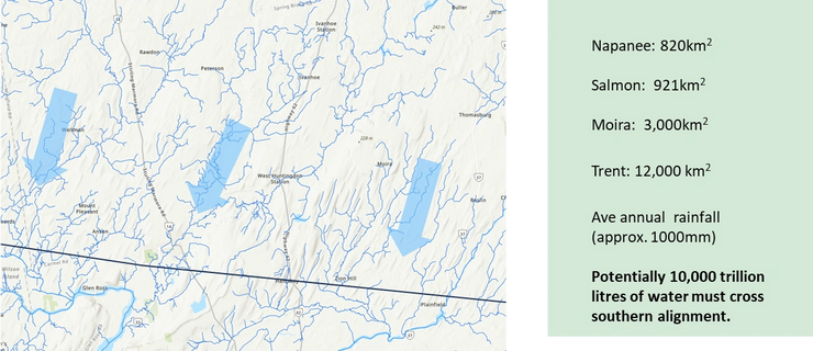
On the northern route, the small streams mostly flow alongside the railway, so the track doesn’t block them. On the southern route, several major rivers flow directly across the railway’s path, turning every embankment into a potential dam. The volume of water that must be engineered across the southern alignment is orders of magnitude greater.
Route Comparison: Hydrology
| Challenge | Northern Route (Hwy 7 / Canadian Shield) | Southern Route (Frontenac Arch / Agricultural Lowlands) |
|---|---|---|
| Ground stability | ✓ Granite bedrock: essentially permanent, zero post-construction settlement, no mud pumping, no frost heave | ✗ Clay-till soils with seasonally elevated water tables: ongoing consolidation risk, frost heave, expansive clay potential |
| Stream crossings | ✓ Headwater setting with small catchments running parallel to alignment; many seasonal | ✗ More numerous crossings of streams, drainage channels, and tile-drain systems running perpendicular; each requires hydraulic assessment and bridge |
| Wetland interaction | ✓ Elongated wetlands parallel to alignment can be navigated around; blast rubble provides fill material | ✗ Extensive, irregularly distributed wetland complexes; may require piled viaduct sections; secondary drainage impacts on adjacent farmland |
| Drainage engineering | ✓ Simpler: cut sections in rock drain naturally; embankments on stable, well-drained granular material | ✗ Complex: sealed subgrade layers, permeable shoulders, blind ditches, extensive interceptor ditch systems required throughout |
| Cost profile | ✓ Acute: blasting and rock removal are expensive but front-loaded and finite | ✗ Chronic: more stream crossings, more drainage infrastructure, potential soft-ground treatment; costs distributed and ongoing |
| Long-term risk | ✓ Low: rock foundation does not change; drainage system simple to maintain | ✗ Moderate to high: clay consolidation continues for years; drainage systems require ongoing inspection; any failure requires expensive slab track repair |
Key Distinction
The northern corridor’s hydrological challenges are predictable and manageable, especially in the Mazinaw terrane rocks, and inherently stable once built. The southern corridor’s hydrological challenges are chronic, embedded in the operational lifetime of the line as an ongoing obligation for monitoring, drainage maintenance, and potential ground remediation. For a line intended to operate for 60–100 years, this distinction matters enormously. Chinese HSR experience suggests that 20% of the cost to build will be required for maintenance between 20–30 years of operational life [1]. A route through the southern corridor will require substantially more ongoing drainage maintenance, making it a significantly more expensive choice over a 60-year horizon.
What must be done before a route decision
The hydrological analysis above has several direct implications for the ongoing ALTO public consultation and the environmental assessment process that must follow.
Conduct and publish a rigorous hydrological baseline study
This must include mapping of watercourses, floodplain extents, wetland complexes, tile drainage systems, and groundwater depths along the entire study area. Desktop assessment from aerial photography and existing mapping is insufficient for a project of this magnitude.
Publish the number and character of watercourse crossings for each corridor
The crossing inventory should be a published input to the route comparison, not a detail left to the environmental assessment phase. Each crossing is a known cost driver and regulatory trigger.
Include whole-of-life costs in route comparisons, not just construction costs
ALTO’s claim that the southern corridor “simplifies construction” is contradicted by the hydrological evidence. Favourable rock types across a 50 km traverse of the northern shield, compared to the drainage engineering, stream crossings, and soft-ground treatment on the southern route, are expected to favour the northern corridor by more than 40% in whole-of-life cost terms [1].
Formally engage the Conservation Authorities covering both corridors
Rideau Valley, Cataraqui Region, Quinte, and Lower Trent Conservation Authorities should be formally engaged in the consultation process. Their regulatory role in floodplain and wetland management will be triggered by any route construction.
This is not “rock vs. farmland”
The public conversation about ALTO’s route should not be “rock vs. farmland.” It should be about what happens over 60–100 years beneath the track: how water behaves, what it costs to manage, and which corridor offers a foundation that is stable enough to meet the extraordinary precision that high-speed rail demands, permanently.
The consultation is open until April 24. Every comment submitted becomes part of the official record that Alto must consider when recommending a route. Make yours count.