Tag: route alignment

  • Development ethics for Alto

    Guest Submission · Development Ethics

    Development Ethics for Alto

    Brief to the Alto online public consultation

    JD
    Jay Drydyk
    Professor Emeritus, Carleton University
    Past President, International Development Ethics Association
    Publisher’s Note

    The ALTO HSR Citizen Research Initiative is pleased to publish this guest brief with the author’s permission. It is reproduced as written; the analysis, rankings, and recommendations are Dr. Drydyk’s own. Footnotes appear as endnotes at the foot of the page.

    Section 1

    The contractor and the public

    Suppose our roof is damaged, and we are restricted by our bank to dealing with only one contractor for the repair. The contractor tells us there are two options, A and B, both of which are risky and expensive. Then we find out there is a third option, which is not so risky or expensive. The contractor has not only concealed this from us but now refuses to talk about it.

    Is this an ethically acceptable way of doing business? No, it seems to violate basic values of honesty and transparency.

    By analogy, this seems to be how Alto has tried to do business with us as a public. The roof is our broken inter-city transportation system. The two expensive and risky options are two new high-speed rail [HSR] corridors put forward in the Alto project proposal of 2025-26. What I will call the ‘northern Shield corridor’ lies north of Highway 7, and what I will call the ‘Frontenac/Napanee corridor’ lies south of Highway 7. Farther south another corridor already exists, along the CN right of way and Highway 401. This third, most southerly corridor is the one that Alto is reluctant to discuss.1

    To put this in another way, the imaginary contractor and the real agents of Alto are both selling their solutions with logical fallacies. The contractor tells us: you need to fix your roof, so you need my options A or B. Alto: you need to fix your broken transportation system, so you need a new transportation corridor. Neither argument follows, because in each case there is a third option.

    Section 2

    Good development vs. maldevelopment

    Some development is worthwhile, but some is quite undesirable; this is an ethical difference, based on values, and with 80 years of post-WWII experience we know a lot about what these values are. Worthwhile development not only produces more, it also enhances people’s well-being and freedom, so that they are better able to shape their own lives for the better; it also does so equitably and sustainably. These are the pillars of what has been identified as a worthwhile ‘human development’ approach by the influential economist Mahbub ul Haq in collaboration with Nobel laureate Amartya Sen.2

    Meanwhile, other development researchers have studied what these broad values require in practice in cases of development projects (like Alto) that involve land-taking.3 Some guidance can be found in national legal systems, in international human rights law, and in operational policies of international financial institutions. Yet the evidence shows that ‘even when all three approaches are applied consistently, outcomes … are generally still poor’, impacting negatively on the livelihoods and well-being of people affected.4 A recent synthesis of this research has formulated six guiding principles to fill these gaps. Three of these are most significant for the Alto proposal:

    2. Fair procedures: promote inclusive decision-making through a fair and transparent procedure from the outset and throughout the lifecycle of the project;

    3. Fair distribution: ensure a fair distribution of impacts and benefits and align with the Sustainable Development Goals;

    6. Remedy and accountability: ensure remedy and accountability through access to grievance redress mechanisms, remediation and legal recourse.5

    These values and principles help to distinguish between good development and maldevelopment in five dimensions of the Alto proposal: public interest, landowner impact, community impact, environmental impact, and Indigenous peoples’ consent.

    Section 3

    Public interest, public need

    Development ethics tells us that people should not be displaced and land should not be taken for development except for projects that are in the public interest.6 What does ‘public interest’ mean here? It means that the gains or advantages created by the project are not entirely private gains, that very significant gains accrue to us as a public. An important standard of public interest is public need. Building schools and hospitals involves land-taking, by which some residents may be displaced, and yet there is great gain to the public, in having schools and hospitals, simply because schools and hospitals are things we need, as a public. This does not entail that building a particular school in a particular place is the best way to meet this need, but it does give very strong reason for building some such school where it is most needed.

    The term ‘high-speed rail’ has been used with different meanings in recent discussions, and so I want to be clear that what I will mean is rail service with maximum speeds faster than 200km/hr. This range corresponds with the definition of HSR by the International Union of Railways.7 This range includes what Alto means by ‘high-speed’, which is faster than 300km/hr, but it also includes speeds in the 200 range. Unlike the Alto definition (>300km/hr), the broader UIC definition captures the majority of high-speed rail services currently offered in Japan and Europe.8

    There is a strong case that high-speed rail, in this sense, is a public need in Ontario and Québec. According to this argument, HSR is needed to shift people’s choices in the Ontario-Québec corridor from airplanes, cars, and buses to trains. This is needed for two main reasons. First, continued reliance on cars, buses, and airplanes, for generations to come, has an unacceptable carbon footprint, which will contribute to ever greater loss of life, property, homes, and habitats through climate change. Second, continued reliance on cars, buses, and airplanes imposes a drag on economic productivity, putting downward pressure on livelihoods and well-being throughout the economy. For these two reasons, it is argued, we have a long-term need to change the mode of inter-city transport in this corridor, and, to achieve this we have a long-term public need for high-speed rail.9

    However, this does not determine where and how HSR should be built – with one exception. Building HSR stations at locations removed from city centres defeats the purpose of HSR (for travelers) by adding commuting time to reach the stations.10 As to where and how HSR is built, public benefit is only one value that matters: we also have equity/fairness/justice and sustainability to consider. There are equity issues pertaining to landowners, communities, and Indigenous peoples, which I will consider in the next three sections; environmental values will be considered in section 7. All of these raise further issues of accountability.

    Section 4

    Landowner impact

    When we notice unfairness or injustice, we are perceiving some kind of deprivation as being wrong. Even if a development project meets public needs and creates public benefits, our intuitive sense of justice will object if the project imposes unwarranted burdens and harms on others. It remains true for cooking that, ‘If you want make an omelet you have to break some eggs,’ – but not as a metaphor excusing harmful development. Thus it is widely accepted that development projects should not make people worse off, either by displacing them from their land, or through other community impacts.11

    Paying people market value for the land that is taken from them may still leave them worse off. One reason is the impact of land-taking on livelihoods. When his land was assessed for compensation by an oil pipeline project, a Ugandan farmer remarked, ‘I had 10 mango trees where I used to make a lot of money every season and look after 11 dependents, we got only 670,000 [shillings] … they didn’t think about the capital value required to plant new trees and how many years it would take us to start harvesting fruits again.’12 The Alto project does not threaten any mango trees in Eastern Ontario, but it does threaten to impact livelihoods by dividing farms. It may be possible to mitigate these effects, but it would be complicated: organizing and paying for land swaps so that each farm is made whole by other land on the same side of the fenced-off right of way. One challenge of land replacement strategies like these is to ensure that the replacement land is of as good quality as the land lost. If this is not possible, compensation for lost revenue/livelihood would require revenue sharing plans on the part of the project.

    The Ontario Federation of Agriculture has stated:

    It is not acceptable for any railway to divide properties and thereby “landlock” the interior of the lot. Any crossing must be at least 10 metres wide to allow large and irregularly shaped farm and forestry equipment to be conveyed safely across the railway. Over- and underpasses must be engineered to accommodate the weight, height, and width of not only today’s farm and forestry equipment but also what machines may be used in the future. Crossings must also be engineered to prevent equipment rollovers. Alto must also preserve drainage system functionality and not adversely affect natural drainage systems.

    Alto has stated that the entirety of the railway corridor will be fenced. Alto must consult on the fencing design to ensure farm animals cannot stray onto the tracks, as some farm animals have special fencing needs.

    In addition, Transport Canada and Alto must provide fair and proportionate compensation for other negative affections caused by the railway, which will permanently affect farm production and limit growth potential.13

    The issue here is equity: if these effects are not fully mitigated and/or compensated, the farmers will bear special burdens for the building of high-speed rail – as if an arbitrary high-speed rail tax were imposed upon farmers on whose land track was laid.

    Currently no accountability mechanisms have been established to ensure that such mitigations and compensations are carried out, and to which landowners can seek recourse in case mitigation and compensation are not carried out. Government has an ethical obligation to establish such mechanisms before making a final investment decision.

    Section 5

    Community impacts

    According to Alto:

    However, this same railway separation also has other consequences for human security. Limited overpass/underpass crossings may increase distances and times for fire and ambulance services, potentially causing fatal delays.15 These security gaps can be mitigated by careful planning of overpasses and underpasses; mitigation plans should be agreed with the municipalities responsible for delivering these services. Best practices of high-speed rail systems in other countries should be followed.

    Once again accountability is a problem. To date no accountability mechanisms have been established to ensure agreement and planning for timely fire and emergency health services after Alto rail lines have been built and separated from roadways. Nor is there any body to which municipalities can seek recourse in case such agreement and planning do not occur, or in case agreements are not fulfilled. Government has an ethical obligation to establish such mechanisms before making a final investment decision.

    If the Frontenac/Napanee or northern shield corridors are chosen for HSR, existing VIA service will be impacted by service cuts as longer-distance travellers shift to HSR. At present Kingston is the fifth-busiest passenger train station in the country. There is a public need to maintain viable service for these passengers and others from stations along the existing VIA corridor. Moreover, community impacts from Alto would reach far beyond eastern Ontario. If 80% of VIA revenue currently comes from passengers travelling in the Windsor-Québec corridor, and much of this is diverted to Cadence as operator of HSR between Toronto and Québec, much less will be available to support other major VIA trains, such as: Montréal-Halifax (‘The Ocean’); Toronto-Vancouver (‘The Canadian’); Winnipeg-Churchill; Jasper-Prince Rupert; Sudbury-White River; Montréal-Jonquière/Senneterre. Allowing these train services to be degraded or discontinued would constitute a clear neglect of public interest. Accordingly, the Alto HSR Citizens Research Initiative has called for two immediate legislative responses:

    Statutory Service Guarantee for the Kingston SubdivisionAny federal legislation enabling ALTO must include a statutory charter guaranteeing minimum VIA Rail service levels on the Kingston Subdivision. The charter must specify minimum daily frequencies, protect morning and evening service windows, and require public consultation before schedule changes affecting intermediate communities.

    Dedicated, Legislated Funding for the National Rail NetworkParliament must establish a dedicated funding stream for VIA Rail’s non-corridor network — The Ocean, The Canadian, and remote services — entirely independent of corridor revenue that will transfer to Cadence. This fund must be protected as a condition of any ALTO implementation agreement.16

    The appropriate timing for such legislative action would be as close as possible to the final investment decision on the Alto project.

    Section 6

    Indigenous peoples’ consent

    Alto has stated, ‘We are committed to engaging in meaningful consultations with the aim of securing the Free, Prior, and Informed Consent (FPIC), of potentially impacted communities.’17 The phrasing is ambiguous. Are they committed to achieving FPIC, or only to holding ‘meaningful consultations with the aim’ of doing so? The UN Declaration on the Rights of Indigenous Peoples is unambiguous on this point.

    Meaningful consultation is not the end; it is only a means to achieving ‘free and informed consent prior to the approval of any project affecting their lands or territories and other resources’.

    The earlier High Frequency Rail project which preceded Alto included consultation with ‘more than 40 potentially impacted Indigenous communities and organizations’.19 However, that consultation focused entirely on supplementing the Request for Proposals with provisions for Indigenous social benefits and participation. There was no mention of consent with regard to impact on Indigenous territory; in any case, the Request for Proposals for HFR has been superseded by the Alto HSR proposal awarded to Cadence, now in co-development phase. Site selection and alignment have not yet been specified by Alto and Cadence. At the present time it is unclear whether any discussions have been undertaken with the Mohawk of the Bay of Quinte in Ontario or the Mohawk of Kanesatake in Quebec about use of or impact on their territories. Nor is there any evidence of commitment to recourse or accountability mechanisms for benefit/land/participation commitments that will be made to them.

    Section 7

    Environmental Impact

    For the route through the Frontenac Arch and Napanee Plain, environmental risks are significant. For the northern route largely over Canadian Shield, risks are less clear. For the southernmost corridor, environmental risks have already been incurred by the CN right of way and Highway 401; one would expect additional risks from HSR to be small by comparison. Doing nothing to shift travelers over to rail also incurs the environmental risks incurred by flying and driving, notably contributions to climate change. The difficult question is actually the normative question: which risks must be avoided? If worthwhile development is environmentally sustainable, then the answer is that we must avoid risks that are unsustainable, and this shifts the question to: what are the meaning and standards for sustainability?

    While precise answers to these normative questions are elusive, two broad ways of framing them have emerged over the past forty years to provide starting points for public deliberation about environmental risks. The 1987 Brundtland Commission proposed that development is sustainable when it meets the needs of present generations without jeopardizing the needs of future generations.20 More recently, the UNDP Human Development Report of 2020 called for steering development to ease the ‘planetary pressures’ that historical and contemporary social and economic development unleash.21 The main idea here is that development puts pressures on the planet, and the planet pushes back in ways that make present and future human flourishing more uncertain. At the extreme:

    Climate change and biodiversity integrity loss are tightly coupled core boundaries, and human activities are currently pushing both of them into a high-risk zone. If humanity breaches planetary boundaries too far or for too long, it may disrupt planetary life support systems, with substantial risks for human life as we know it.22

    The HSR corridor over part of the Frontenac Arch will also traverse an adjoining limestone plain surrounding the Napanee and Salmon Rivers. Under the limestone plain is found karst geology, featuring sinkholes, fissures, caves, and disappearing streams; above it are rare alvar ecosystems based on terrain with thin or no soil cover. These ecosystems harbour several species protected by the Species at Risk Act; it is doubtful that Alto could show that its construction can meet requirements of this Act. Construction would also affect subsurface water flows in unpredictable ways, possibly damaging freshwater access and use downstream. For other ecosystems in other places it may be possible to mitigate environmental impacts of HSR, as for example best practice standards have evolved in Europe for protecting essential pathways for migratory species. If such mitigation strategies can succeed for a CN/401 corridor, or for a northern shield corridor, they must be planned, budgeted, and carried out. However, in the Frontenac Arch and Napanee Plain these particular mitigation strategies may be of no use, due to the combination of karst geology below and alvar ecosystems above. Since biodiversity and freshwater access are two dimensions in which there are planetary boundaries, it follows that, in this corridor, an HSR line would be adding to planetary pressures rather than reducing them. Building HSR in the Frontenac/Napanee corridor, then, qualifies as environmental maldevelopment.23

    In the northern Shield corridor, biodiversity and freshwater impacts may be less pronounced and more amenable to mitigation. The HSR line and its construction are less likely to disrupt water flow in this corridor, where streams run parallel to rail alignment. The line would disrupt movement by larger mammals such as moose, elk, and bear, but these are not species at risk. More research is needed to determine what kinds of mitigation are required; international evidence suggests that there are few types of overpass that large mammals will actually use, and these are quite expensive.24 Effects on other species also requires further study and assessment. A clear standard for wildlife mitigation, with accountability mechanisms, is needed to ensure that adequate mitigation measures are chosen and implemented.

    Section 8

    Ranking the options: from morally worst to not so bad

    These two frameworks – future generations and planetary pressures – can help to orient discussion of environmental and social impacts in ethical, value-based terms. We can consider what will be the result of rolling out the various HSR options over multiple future generations. How will these decisions now affect planetary pressures exerted by humans then? Is it possible to assess or at least imagine how much closer to or in excess of planetary boundaries we get, in each scenario? In light of this, we can rank those options, as to how comparatively undesirable they are, from a development ethics perspective.

    The following rankings are only illustrative, expressing my own moral assessment, based on reasons for concern that I am aware of at the present time. This illustration, however, does have a point, namely that it is plausible and powerful to rank the options before us in terms of their enduring impact both to enhance human well-being and to reduce the dangerous pressures we are placing upon the planetary systems that sustain us. What we need, I conclude, is a public deliberation to make such a ranking.

    1
    Status quo.If there is no replacement for current VIA Rail levels of service, travelers will continue to be shunted into cars, buses, and airplanes to travel between Québec, Montréal, Ottawa, and Toronto (and indeed London and Windsor). The carbon footprint for this travel will grow apace. There being no other proposals on the horizon to compensate, I conclude that continuation of the status quo on VIA Rail will mean continued contribution to the death, illness, and destruction of property and habitats that result from carbon-induced climate change.
    2
    Frontenac/Napanee corridor, without mitigation.Mitigation for landowners and community safety are feasible and morally mandatory; however, for the sake of ranking consider the possibility that it is not carried out, so we have: unnecessary and inequitable loss to livelihoods and human security. In that respect, this option ranks worse than the following one:
    3
    Frontenac/Napanee corridor, with human/community mitigation.Well-being and equity issues in the previous option are removed, but, on the environmental side, ecological mitigation seems unlikely. Over many generations, then, the effects we can anticipate from HSR include (a) expansion of human well-being; (b) reduction in the particular pressures imposed by the carbon footprint of travel between Windsor and Québec; but (c) significantly increased planetary pressures both on biodiversity and on freshwater access.
    4
    Northern Canadian Shield corridor, without mitigation.Although much of this territory is more remote, there are still roads, tracks, and migratory paths that can be cut off by HSR fencing. Human security and wildlife migration will still be impacted unless mitigation measures are adopted.
    5
    Northern Canadian Shield corridor, with mitigation.With landowner and community mitigation, inequitable losses are reduced, so that we can anticipate (a) expansion of human well-being, along with (b) reduction in the particular pressures imposed by the carbon footprint of travel between Windsor and Québec; (c) with mitigation it may be possible to avoid increasing planetary pressures on biodiversity, but this is not perfectly clear, either; (d) adverse impacts on fresh water are less likely. Rolling this forward over multiple generations, we want to ensure monitoring for unforeseen environmental problems. This could be addressed by establishing capability in each region affected by HSR for ongoing environmental monitoring, funded by revenue sharing from operation of HSR service.
    6
    Southern CN/401 corridor, without mitigation.Because this corridor already exists, one might expect fewer new adverse impacts. However, without mitigation, mandatory grade separation and fencing will adversely affect humans and other species alike, which makes this option worse than the final one.
    7
    Southern CN/401 corridor, with mitigationfor community and wildlife impacts to highest standards of European/Asian HSR, with further direction from the environmental assessment. With landowner and community mitigation, inequitable losses are reduced, so that we can anticipate (a) expansion of human well-being. In addition, the problem of depriving service to Kingston is avoided. Over future generations we can also expect (b) reduction in the particular pressures imposed by the carbon footprint of travel between Windsor and Québec. Following best European/Asian practices, modified by site-specific environmental assessment, (c) with mitigation it may be possible to avoid increasing planetary pressures on biodiversity as well as (d) impacts on fresh water. Still, rolling this forward over multiple generations, we want to ensure monitoring for unforeseen environmental problems by establishing, in each affected region, capability for ongoing environmental monitoring, funded by revenue sharing from HSR operation.

    The worst option, according to this, is the status quo. Doing nothing now about intercity travel has the worst impact on well-being and planetary pressures for future generations. The Frontenac/Napanee options are not much better. An independent public panel, I believe, would confirm these rankings and could also shed more light on the others.

    Section 9

    Recommendations to the Government of Canada

    1
    Make corridor proposals public, including the CN/401 corridor. Immediately require Alto to develop and make public feasible alignment plans for (a) the CN/401 corridor, along with any alignment plans under active consideration for (b) the northern Canadian Shield corridor; and (c) the Frontenac/Napanee corridor. Require each of these plans to include cost estimates for wildlife and road crossings at high international standards, for land replacement to maintain farm viability, and for revenue sharing to fund ongoing monitoring of environmental impacts.
    2
    Make corridor choice a public choice. Prior to Final Investment Decision, appoint an independent public panel to recommend choice between corridor proposals (including the status quo), (a) on grounds of public interest, community impact, and environmental impacts/pressures; (b) considering these impacts for several generations (c) with powers to modify any proposals submitted, and (d) with a mandate to recommend mechanisms of recourse and accountability.
    3
    Obtain Indigenous peoples’ consent. Prior to Final Investment Decision, ensure that free and informed consent to impacts on their lands has been given by affected Indigenous peoples, along with mechanisms of recourse and accountability for community and environmental impacts on those lands as well as for commitments to Indigenous participation and community benefits.
    4
    Establish accountability mechanisms and environmental monitoring. Withhold Final Investment Decision until mechanisms of recourse and accountability have been established to support commitments for (a) landowners, (b) communities, (c) wildlife impacts, and (d) Indigenous communities. Do not invest in an HSR proposal that does not allocate revenue in the operational phase for ongoing regionally-controlled environmental monitoring.
    5
    Protect VIA Rail with legislation and funding. Establish service levels and funding streams for regional service along the Windsor-Montreal corridor and for VIA Rail’s non-corridor network – The Ocean, The Canadian, and remote services.
    Section 10

    Recommendations to Alto

    A1
    Corridor proposals. From the perspective of development ethics, corridor choice is not yours to make; this is properly a public choice. Accordingly, you are obligated to prepare development options for all of the feasible HSR corridors, to facilitate public choice among them.
    A2
    Request and obtain Indigenous people’s consent. Ensure that free and informed consent to impacts on their lands has been given by affected Indigenous peoples.
    A3
    Negotiate livelihood replacement. In negotiating with landowners, ensure that compensation covers livelihood replacement (including, for farmers, drainage and access to fields), including revenue sharing if necessary.
    A4
    Negotiate revenue sharing for ongoing regionally-controlled environmental monitoring during the operational phase.
    A5
    Negotiate mechanisms of recourse and accountability to support commitments made for (a) landowners, (b) communities, (c) wildlife impacts and environmental monitoring, and (d) Indigenous communities.
    References

    Notes

    1
    ALTO HSR Citizen Research Initiative, How History Led Us Here, March 2026, citizenresearch.ca/how-history-led-us-here, and Where We Stand on the Route, altohsrcitizenresearch.ca, accessed April 9, 2026.
    2
    Mahbub ul Haq, Reflections on Human Development (Oxford: Oxford University Press, 1995). Amartya Sen, Development as Freedom. (Cambridge, MA: Harvard University Press, 1999.
    3
    Peter Penz, Jay Drydyk, and Pablo Bose, Displacement by Development: Ethics, Rights, and Responsibilities (Cambridge: Cambridge University Press, 2011).
    4
    Smyth, Eddie, Susanna Price, and Frank Vanclay, ‘Fair and Equitable Land Access (FELA) by Development Projects: Enhancing Governance for Sustainable Development Outcomes When Projects Displace People,’ (Sustainable Development 2025, p. 3.
    5
    Ibid.
    6
    Penz, Drydyk, and Bose 2011, p. 211.
    7
    Union Internationale des Chemins de fer (UIC), ‘The Definition of High Speed Rail’ (UIC Communications: 2018). Accessed April 13, 2026. uic.org.
    8
    Wikipedia, ‘High-Speed Rail in Europe’ (March 31, 2026) en.wikipedia.org. Wikipedia, ‘Shinkansen’ (March 14, 2026) en.wikipedia.org.
    9
    While I find that this argument is sound, it is only fair to note that others disagree. The core argument I have outlined is supplemented with other lines of argument in Alto’s ‘Fast Forward’ document (Alto (VIA HFR – VIA TGF Inc.), ‘Fast Forward: Shaping Canada’s Future with a High-Speed Rail Network’ (March 2025) altotrain.ca) For opposing arguments see Tasnim Fariha, and David Jones, ‘High-Speed Potential, High-Stakes Decisions: The Policy Case for Alto’ (C.D. Howe Institute, December 11, 2025) cdhowe.org, Jerome Gessaroli, ‘Canada’s next Budget Bomb Is the Alto High-Speed Rail Project’ (Macdonald-Laurier Institute, January 14, 2026.) macdonaldlaurier.ca. The Citizens Research Initiative argues for upgrading the status quo to a ‘High Performance Rail’ system with top speeds not exceeding 200km/hr. (Where we Stand on the Route, op. cit.) For arguments that raise complications rather than expressing outright opposition, see also: Johnny Renton, ‘The Good, Bad and Awful of the Alto High Speed Rail Project, and How to Fix the Flaws and Concerns Surrounding It.’ (Substack: Next Stop, Downtown Canada, February 4, 2026) johnnyrenton.substack.com; Kathryn Smith Exon and Egon Terplan. ‘Keeping High-Speed Rail on Track: Learning from Other North American Projects’ (Toronto: School of Cities, June 6, 2025) schoolofcities.utoronto.ca; and Michael Schabas, ‘Alto Conceptual Design and Business Case” (January 12, 2026) available on Google Docs, Google Docs.
    10
    ALTO HSR Citizen Research Initiative, The Station Location Problem (2026) citizenresearch.ca/station-location.
    11
    Penz, Drydyk, and Bose, Chapter 7.
    12
    Nassir Mwanje, ‘Community Perceptions of Fair Compensation in Land Expropriation: Insights from Uganda through a Capability Approach’ (Journal of Human Development and Capabilities, forthcoming).
    13
    Ontario Federation of Agriculture, ‘High-Speed Rail’ (2026) ofa.on.ca/issues/high-speed-rail.
    14
    Alto (VIA HFR – VIA TGF Inc.), Advanced Engineering Driving High-Speed Rail (February 19, 2026) altotrain.ca.
    15
    ALTO HSR Citizen Research Initiative, Fire Services – Citizen Research (March 2026) citizenresearch.ca/fire-services, and Healthcare Access – Citizen Research (March 2026) citizenresearch.ca/healthcare-access.
    16
    ALTO HSR Citizen Research Initiative, ‘VIA Rail on the Kingston Subdivision: Service Erosion, Funding Collapse, and the National Rail Risk from ALTO HSR’ (April 2026) citizenresearch.ca/via-future.
    17
    Alto (VIA HFR – VIA TGF Inc.), ‘Building Together: Indigenous Partnerships in Alto’s Vision’ altotrain.ca.
    18
    United Nations, Declaration on the Rights of Indigenous Peoples (General Assembly, 2007) un.org
    19
    Alto (VIA HFR – VIA TGF Inc.). What We Heard & What We’re Doing Report. 2023. altotrain.ca.
    20
    World Commission on Environment and Development, Our Common Future (Oxford: Oxford University Press, 1987).
    21
    The ‘planetary pressures’ framework is based on several decades of ‘planetary boundaries’ research. To simplify: the core idea is that there are nine specific dimensions of planetary change that range from low risk to growing risk to high risk for human flourishing. Among these, ozone depletion, climate change, biodiversity, ocean acidification, land use change, and freshwater use are most familiar in the public sphere. A good entry point into the literature is Human Development Report 2020: The Next Frontier; Human Development and the Anthropocene, Chapter 2, ‘Unprecedented – The Scope, Scale and Speed of Human Pressures on the Planet’ (New York: UNDP, 2020), pp. 45-68.
    22
    UNDP op. cit., p. 51.
    23
    See Andrew Hyett, How Hydrology Shapes the Design – and Cost – of High-Speed Rail (March 2026) citizenresearch.ca, and the following publications by ALTO HSR Citizen Research Initiative (2026): Potential Effects of High-Speed Rail on the Napanee River citizenresearch.ca/napanee-river-2; A River in the Path of Two Rail Corridors citizenresearch.ca/salmon-river;
    24
    See Hyett op. cit. and two other publications of ALTO HSR Citizen Research Imitative (2026): The Wildlife Crossing Problem citizenresearch.ca/wildlife-crossings; Wildlife Connectivity, Hunting Heritage, and Game Species Habitat: Impacts of the Proposed ALTO High-Speed Rail Corridors citizenresearch.ca.
  • The Stations that aren’t there

    The Stations That Aren’t There

    The tourism ALTO’s line leaves at the station — and the small-town visitor economy an integrated network could reach instead.

    ⚠ A short list of city stops

    ALTO’s mandate fixes seven stations — Toronto, Peterborough, Ottawa, Laval, Montréal, Trois-Rivières, and Québec City — only five of them between the endpoints, and every one a city rather than a recreational town. To hold 300+ km/h, the dedicated new alignment stops as little as possible: the original eastern-Ontario option ran a straight line with no stop between Peterborough and Ottawa. Alto FAQ

    After consultation, the government signalled in June 2026 a strong preference for a more southerly route nearer Highway 401 with a potential Kingston stop, keeping the northern corridor alive but deprioritised; the final alignment is still being assessed. Either way the pattern holds — a handful of city stops, and access by car: ALTO’s own pitch is that most residents east of Peterborough would be within a 25-minute drive of a station. The small towns and shorelines that draw the corridor’s leisure travel sit off the line. CBC

    Critical Finding

    ALTO frames tourism as a metro-connectivity product: faster links between big cities. But the corridor’s large, capturable, and better-distributed tourism opportunity is the opposite trip — domestic leisure travel from the four metros out to smaller towns and recreational areas. That market is already huge, overwhelmingly intra-provincial, mostly same-day, and almost entirely car-dependent.

    This is not small towns instead of big cities. A faster, more reliable High Performance trunk improves the metro trip too — most of the way, since the large gain is over today’s freight-delayed VIA service, not over ALTO. An integrated network reaches the metro market and the small-town market; ALTO’s express spine reaches the first, marginally faster, and by geometry bypasses the second — and can draw activity toward its hub stations rather than distributing it.

    On transparent, adjustable assumptions (a fifteen-minute station catchment, scenario ranges for capture and induced demand), an integrated network could plausibly generate an illustrative band of roughly $30 million to $640 million a year in net-new, locally-retained small-town tourism spending. These are scenario figures, not a forecast; the point is that the benefit is real, net-new rather than displaced, and lands in the communities the express line skips.

    The Market

    A large market, already on the road

    1 in 3
    domestic trips is for holidays, leisure or recreation — the market ALTO’s frame overlooks
    StatCan National Travel Survey
    ~14%
    of domestic travel spending goes to gas and vehicle operation — the leisure market is car-locked
    StatCan National Travel Survey
    ~$200M
    illustrative central net-new small-town tourism per year an integrated network could capture (band ~$30M to ~$640M)
    Initiative scenario

    The domestic leisure market the corridor sits inside is very large. About one in three domestic trips by Canadians is for holidays, leisure or recreation — on the order of ninety-five million such trips nationally in a normal pre-pandemic year — and travel within Canada has since climbed to new highs, with tens of billions of dollars spent each quarter.

    In Ontario, domestic travellers made roughly 116 million visits in a recent full year, over 93 per cent of them Ontarians travelling within their own province; Quebec is the second most-visited province. Most of this travel is same-day — in Ontario about two-thirds — and a same-day trip already means a journey of at least forty kilometres each way.

    And it is car travel. Gas and vehicle operation is consistently one of the three largest categories of domestic travel spending, at around 14 per cent — a direct measure of how car-locked leisure travel to non-metro destinations currently is. Per-visit spending is modest (same-day visits average roughly $70 in Ontario and $75 in Quebec) but the volume is the story.

    This is the demand pool. It is intra-provincial, high-frequency, price-sensitive, and today almost entirely dependent on the private car — which is precisely the market a convenient, well-priced, integrated rail network could convert, and precisely the market a metro-to-metro express line does not address.

    The Geography

    Where the leisure map meets the line

    The test the Initiative applied is simple: which of the corridor’s recreational regions fall within a fifteen-minute reach of a station ALTO is mandated to build? On that test, most do not.

    Recreational regionRelationship to the ALTO line
    Prince Edward County (ON)No station. The nearest existing rail town, Belleville, is bypassed by the northern alignment. Unserved.
    Thousand Islands / Gananoque (ON)Hinges on the Kingston stop, under assessment since June 2026 on the preferred southern route. If confirmed, Kingston would interconnect the existing VIA station and serve as a genuine gateway — though access stays a drive-to-station model. Conditional.
    Northumberland shore — Cobourg, Port Hope (ON)The line routes inland via Peterborough, away from the lakeshore towns and their existing rail. Unserved.
    Kawarthas (ON)Peterborough is a mandated stop and a genuine gateway. Served.
    Rideau corridor — Perth, Westport, Smiths Falls (ON)Off the alignment; no station. Unserved.
    Eastern Townships / Cantons-de-l’Est (QC)South of Montréal, off the Québec-bound line. Unserved.
    Mauricie (QC)Trois-Rivières is a mandated stop and a gateway. Served.
    Charlevoix (QC)Northeast of Québec City, far beyond the line’s end. Unserved.
    Laurentians / Mont-Tremblant (QC)North of Laval; the resort areas lie well beyond any mandated station. Unserved.

    Three of the stops are real recreational gateways, and this brief counts them as such: Peterborough for the Kawarthas, Trois-Rivières for the Mauricie, and — if confirmed — Kingston for the Thousand Islands. But even among these, ALTO’s own materials place Peterborough and Trois-Rivières at the city’s edge, near highways rather than in the centre; only a Kingston stop, reusing the existing VIA station, would set a visitor down in the town itself. The pattern is nonetheless clear: the station set is a list of cities, and whether the eastern-Ontario segment runs north or on the preferred southern line, it stops at cities and passes the belt of small towns and shorelines where corridor residents actually spend their leisure time.

    The Mechanism

    An express spine concentrates; it does not distribute

    Two features of a 300+ km/h line work against dispersed tourism. The first is stop spacing. High speed is only worth building if the train rarely stops; every added station erodes the time saving that justifies the cost. A line optimised for Toronto–Montréal in about three hours cannot also be a network of small-town halts — the two objectives are in direct tension, and the metros win.

    The second is the straw effect (sometimes the tunnel effect), one of the better-documented findings in high-speed-rail economics: fast, few-stop lines tend to concentrate activity in their terminal cities and can draw it out of the places they pass. For tourism specifically, a traveller moved from metro to metro in three hours has no reason to stop in between, and the towns without a platform capture nothing. The honest reading is therefore not that ALTO is merely unhelpful to small-town tourism, but that its geometry can be actively adverse to it.

    An integrated High Performance network works the other way. A trunk at 180–240 km/h on existing corridors, with regional feeders and timed local connections, trades a little top speed for many more points of access — and it is the access, not the speed, that unlocks the leisure trip.

    Couldn’t ALTO just add the last-mile links?

    It could, and it says it will: ALTO has publicly stated it wants the network interconnected with the REM and metro in Montréal and Laval, the LRT and VIA in Ottawa, and the same in Kingston. Municipal and regional-transit integration is a policy choice open to any operator, not a property of one technology. But last-mile links work on top of stations — they amplify access at stops that exist; they cannot create a stop where the line does not run. And ALTO’s own access model is drive-to-station: its selling point for the Kingston option is that most residents east of Peterborough would be within a 25-minute drive of a platform — car-dependent access, the opposite of the car-free leisure trip. The binding constraint is the number and placement of stops, and no shuttle programme changes it.

    The comparison is both-and, not either-or

    High Performance Rail does not trade the metro trip away to reach the small towns; it improves both. A more frequent, more reliable trunk on dedicated track would substantially boost metro-to-metro leisure travel over today’s freight-delayed VIA service — and most of that gain comes from leaving freight-priority track, not from the final increment of speed. The Initiative’s own analysis finds ALTO’s extra 17 to 25 minutes per city pair is a small addition to a benefit High Performance Rail has already largely captured. So an integrated network reaches the metro market and the small-town market; ALTO reaches the first, marginally faster, and forecloses the second.

    Even where ALTO stops, the platform tends to sit outside the centre

    The design privileges speed over central access, and the station choices show it. The one true downtown terminal, Montréal, depends on a tunnel of more than ten kilometres under the Rivière des Prairies and Mount Royal — costed by a McGill analysis at over a billion dollars a kilometre, some 12 to 18 per cent of the whole $60–90 billion budget. As the single most expensive discrete element on the line, with a suburban Laval station already built into the first phase, it is the obvious thing to defer or drop if costs run over — as, on megaproject form, they will. The others already point the same way: by ALTO’s own CEO, Toronto’s first station will be suburban, opening ahead of any downtown stop; the Transport Minister has set aside the historic downtown Ottawa station on cost and geology grounds; Québec City’s central Gare du Palais is largely ruled out as too slow; and Peterborough, Trois-Rivières and Laval are sited near highways and open land to hold the 300 km/h line. Should the Montréal tunnel go the way of the others, not one of the four major anchors would be left with a secure downtown station. Where the design builds fresh for speed, the platform lands outside town and the visitor arrives by car — the opposite of the car-free leisure trip. The one honest exception is reuse: at Ottawa’s Tremblay hub and a possible Kingston on the VIA line, ALTO leans on an existing transit-connected station and access works — which is exactly the High Performance model of keeping the platform where the town already is.

    The Estimate

    A transparent scenario, not a forecast

    The following is deliberately built as visible arithmetic. Every input is a parameter the reader can change; the three columns are a low, central, and high scenario rather than a single prediction. The catchment is set at the fifteen-minute reach used for the geography test above.

    Parameter (annual, at maturity)LowCentralHigh
    Addressable leisure-trip pool — metro origin, destination within 15 min of a networked station3.0M6.0M9.0M
    × Rail capture of addressable car trips10%20%30%
    = Shifted rail trips0.30M1.20M2.70M
    × Induced-demand uplift+10%+25%+40%
    = Rail leisure trips at maturity0.33M1.50M3.78M
    × Net local spend per trip (blended same-day / overnight)$90$130$170
    = Annual net-new local tourism spend~$30M~$195M~$640M

    Illustrative scenario arithmetic. Each parameter is an input, not an observation; the central column is one plausible path through the band, not a point forecast. Pool figures represent a single-digit-millions slice of the corridor’s tens of millions of annual leisure trips.

    Read as a band, an integrated network plausibly captures somewhere between a few tens of millions and roughly $640 million a year in net-new, locally-retained small-town tourism spending, with a central illustrative figure near $200 million. The width of that band is the honest expression of the uncertainty; narrowing it is a modelling exercise, not a rhetorical one. What matters for the comparison with ALTO is not that the high scenario approaches ALTO’s $800 million claim, but that these are net-new and locally-retained dollars — not the gross, un-netted, metro-concentrated figure ALTO reports — and that they land in the communities the express line bypasses.

    The Reference Class

    Integration is the unlock — the Swiss test

    The case that rail can distribute tourism to small towns is not hypothetical; it is the everyday reality of the most integrated networks. Switzerland is the standing proof of concept: timed-transfer scheduling, a single ticketing system, and regional and postbus connections that reach valley and lakeside towns make car-free leisure travel the default rather than the exception, and tourism spending is spread across small communities precisely because the network reaches and connects them. The United Kingdom’s community-rail partnerships show the same mechanism at modest scale, turning secondary lines into local visitor economies.

    The reference class also carries its warning, which this brief states plainly: where fast lines are built without that integration, the straw effect can leave intermediate places worse off, as parts of the Japanese experience show. The lesson is consistent in both directions. It is integration — ticketing, timed connections, and last-mile links — not raw speed, that determines whether rail distributes tourism or concentrates it. That is a choice about network design, and it is the choice an express spine makes in one direction and an integrated High Performance network makes in the other.

    The Condition

    The benefit is conditional, and the brief says so

    This estimate carries a load-bearing assumption, and honesty requires naming it. The entire small-town dividend depends on the last mile actually existing: a train to a rural station accomplishes little if the visitor still needs a car on arrival. The captured trips in the scenario above are conditional on shuttles, regional transit, bike and e-bike hire, and timed connections being built and funded alongside the line. Where that integration is absent, capture rates collapse toward the low column. This condition is not unique to the alternative — ALTO’s own city stations need last-mile links too, and it is pursuing them; the difference is reach, since integration can only amplify the stops a network has, and an integrated network simply has more of them, closer to the destinations.

    Three further limits keep the estimate disciplined. Some premier recreational areas — dispersed cottage country, backcountry, and lakes reached only by private road — are intrinsically car-shaped and fall outside the addressable set at any catchment. Leisure demand is sharply peaked by season and weekend, which is capacity-inefficient and weakens the operating economics rather than strengthening them. And the induced-demand component is the softest parameter in the model; over-reading it would repeat exactly the optimism bias the Initiative documents in ALTO’s own forecasts. The scenario is built to resist that temptation, which is why the low column is deliberately austere.

    Where things stand · July 2026

    Summary ledger

    On the tourism question, measured against ALTO’s own framing:

    Overlooked
    Market — one in three domestic trips is leisure, and the corridor’s small-town leisure economy is large and car-locked. ALTO’s frame addresses metro-to-metro travel, not this market.
    Bypassed
    Geography — most recreational regions fall outside a fifteen-minute reach of any ALTO station; whether the line runs north or on the preferred southern route, it stops only at cities. Peterborough, Trois-Rivières, and (if confirmed) Kingston are the exceptions.
    Adverse
    Mechanism — an express spine concentrates activity in hub cities and can draw it out of bypassed towns (the straw effect), rather than distributing it.
    Available
    Alternative — an integrated High Performance network reaches the metro market (most of ALTO’s benefit, over VIA) and the small-town market: an illustrative central ~$200M a year in net-new local spend, band ~$30M to ~$640M.
    Conditional
    Condition — the dividend is contingent on last-mile integration being built and funded; absent it, capture falls to the low scenario.

    ALTO reports an $800 million annual tourism benefit as a gross figure, concentrated in the metros its line connects. This brief does not dispute that rail generates tourism value between the metros — High Performance Rail delivers most of that too, over today’s VIA service, and at a fraction of the cost. It adds the value ALTO leaves out: the leisure trip out of the city to the small town. One approach captures both markets; the other captures the first, marginally faster, and skips the second. The difference is a network built to stop, not a spine built to skip.

    Download Full Brief
    The Stations That Aren’t There (PDF)
    Small-town tourism and the express spine — the full brief with sources.
    Download PDF
    Sources

    Documents and data

    1.
    ALTO, Frequently Asked Questions and About Alto — the seven federally mandated stations (Toronto, Peterborough, Ottawa, Laval, Montréal, Trois-Rivières, Québec City). altotrain.ca
    2.
    CBC News, coverage of the ALTO route, schedule and land-access surveys, March 2026 — station list, Ottawa–Montréal first phase, and concerns from communities on existing rail routes. cbc.ca
    3.
    The Canadian Press, “Toronto area could get two high-speed rail stations,” April 30, 2026 — seven mandated stops, a possible eighth in the Toronto suburbs, and the 72-trains-per-day service concept.
    4.
    CBC News and Ottawa Business Journal, June 22–23, 2026 — the government’s stated preference for a southern route with a potential Kingston stop interconnecting VIA, the “25-minute drive” catchment claim, and ALTO’s stated intent to connect with the REM, metro, LRT and VIA. cbc.ca obj.ca
    5.
    Station-siting reporting, 2026: ALTO network map (Peterborough near major roadways with bus connections; a northern approach studied at Trois-Rivières owing to downtown density; a Mount Royal tunnel to reach downtown Montréal). altotrain.ca The Canadian Press and The Globe and Mail on Toronto’s suburban-first station opening ahead of a downtown stop; The Globe and Mail and CBC on the Transport Minister setting aside the historic downtown Ottawa station in favour of the existing Tremblay VIA/O-Train hub; and Imbleau largely ruling out Québec City’s Gare du Palais. theglobeandmail.com cbc.ca On the downtown Montréal tunnel — more than ten kilometres, costed by a McGill analysis via The Canadian Press at over CA$1 billion per kilometre, or 12 to 18 per cent of the project budget: trains.com
    6.
    Statistics Canada, National Travel Survey — domestic leisure-trip volumes, same-day share, mode, and expenditure categories (including gas and vehicle operation). Tables 24-10-0070-01 and 24-10-0071-01. statcan.gc.ca
    7.
    Statistics Canada, The Daily, National Travel Survey and Visitor Travel Survey, 2025 quarters — recent domestic tourism spending and per-visit averages for Ontario and Quebec. statcan.gc.ca
    8.
    Reference class (qualitative): the Swiss integrated rail and travel system (timed transfers, single ticketing, regional and postbus links); the United Kingdom’s Community Rail Partnerships; and the high-speed-rail “straw / tunnel effect” literature, including Japanese Shinkansen studies.
    9.
    ALTO HSR Citizen Research Initiative, modal-shift research notes and the scenario methodology set out in this brief — fifteen-minute station catchment, and low / central / high ranges for rail capture, induced demand, and per-trip local spend.
  • Sixth in NA

    Sixth in North America

    What the ranking actually measures — and the route it does not describe.

    ⚠ Source: Disclosed under the Access to Information Act

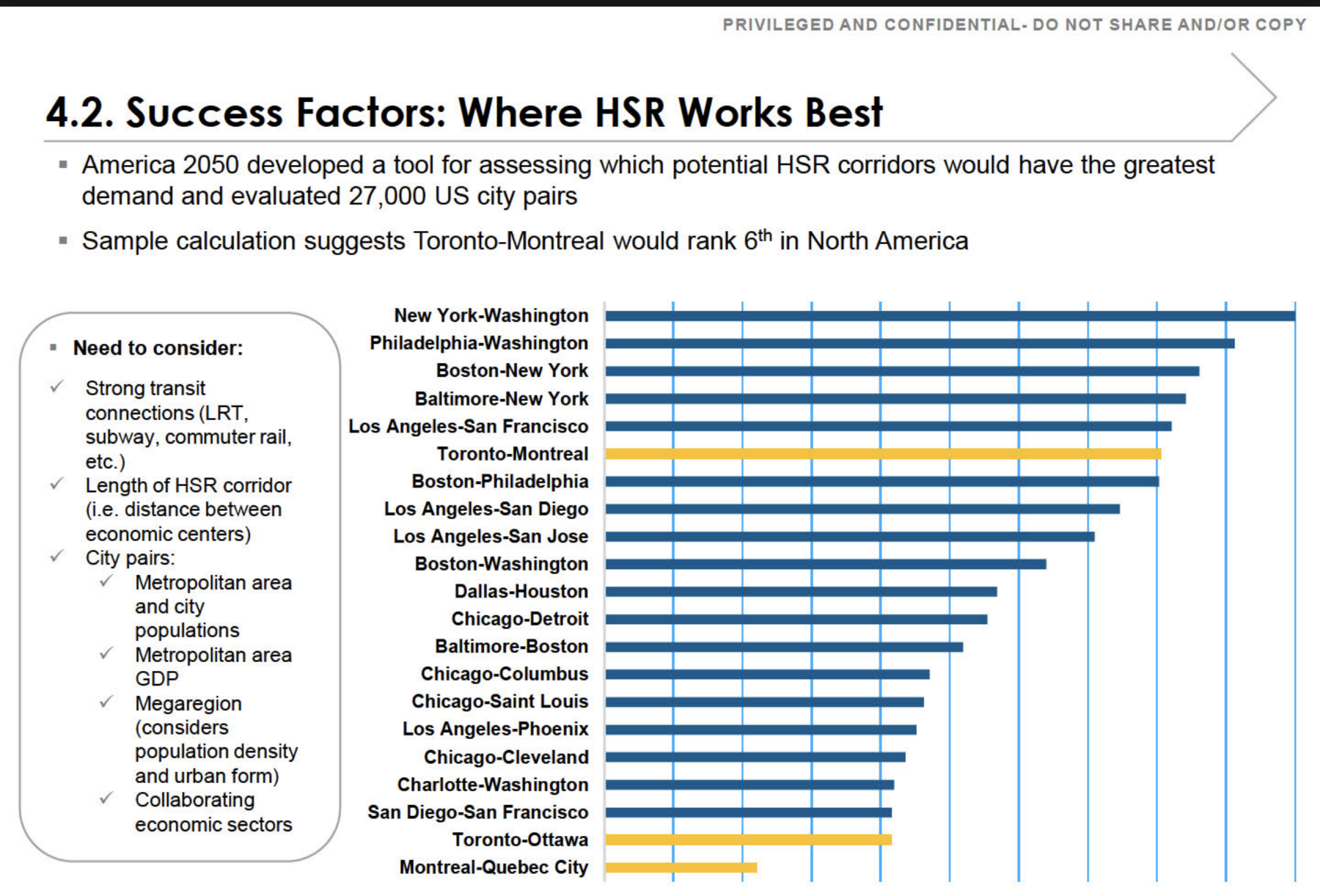
    The slide below is page 206 of a 294-page record released by the Canada Infrastructure Bank under access request A-2022-005 — a request for all studies, analyses, and reports related to the federal government’s high-frequency and high-speed rail file, disclosed in part. The briefing deck it belongs to is stamped “Privileged and Confidential — Do Not Share and/or Copy,” and its own footer marks it “DRAFT.” Adjacent pages were withheld under the Act’s economic-interest and advice exemptions (s. 18 and s. 21). The deck, as disclosed, is posted in full here: Ministerial Briefing — HFR and HSR (PDF).

    The marking is part of the point: this is a draft analysis the department preferred not be seen, and it is the evidence being used to vouch for the corridor.

    Briefing slide: Success Factors, Where HSR Works Best, ranking North American city pairs by high-speed rail demand
    Section 4.2, “Success Factors: Where HSR Works Best.” Page 206 of the Canada Infrastructure Bank release, A-2022-005 (disclosed in part; marked DRAFT). The three highlighted bars are Toronto–Montreal, Toronto–Ottawa, and Montreal–Quebec City.
    The finding in brief

    The slide ranks Toronto–Montreal sixth among North American city pairs for high-speed rail demand. The ranking is real. What it measures is the market between two endpoint metros — not the route now being built.

    The number describes the direct Toronto–Montreal corridor. The alignment taking shape runs Toronto–Peterborough–Kingston–Ottawa–Montreal — a longer, meandering route. On the very methodology the slide cites, every one of those detours lowers the score rather than raising it. And the segment actually proceeding first, Ottawa–Montreal, does not appear on the chart at all.

    The Methodology

    What the ranking measures

    The “sixth in North America” figure comes from America 2050’s screen of tens of thousands of city pairs, a methodology published in full by the Regional Plan Association. It scores the market between two endpoint metros: downtown employment, population density, transit reach, and the existing air and road travel between them. On those inputs Toronto–Montreal scores well. The endpoints are large, dense, and already heavily travelled.

    Two features of that method decide everything that follows, and both are explicit in the source.

    It is calculated per mile. Adding distance without adding a major generator pulls a corridor’s score down, not up. The screen normalizes precisely so that longer routes cannot coast on length.

    Intermediate stations only help when they are themselves large. The report is clear that longer corridors out-rank shorter ones only when the cities in between are medium or large generators. Otherwise the additional miles are a penalty. The top-ranked corridor on the chart, New York–Washington, scores as it does because the dense intermediate cities of Philadelphia and Baltimore sit directly on the shortest path between the endpoints.

    The Route

    The corridor on the chart is not the corridor being built

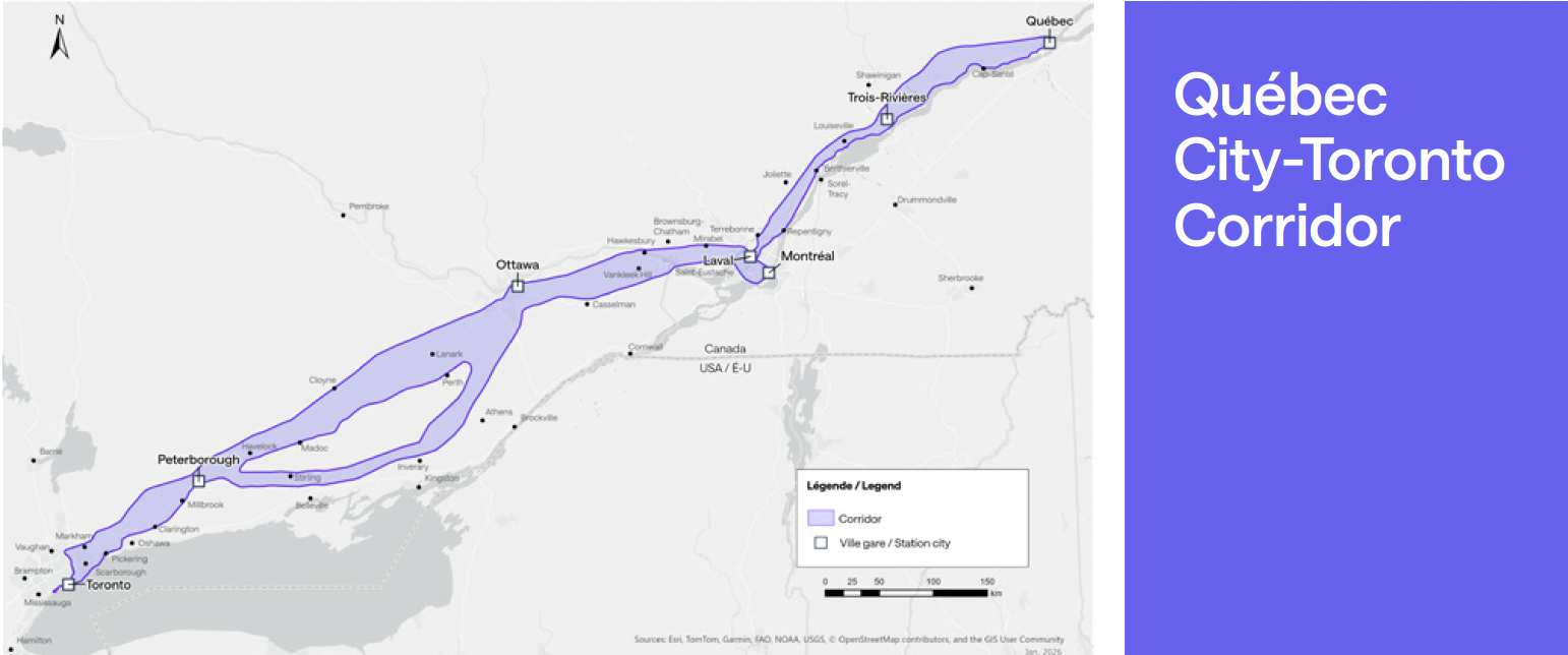
    The favourable score belongs to the direct Toronto–Montreal market — the existing lakeshore line, the shortest path, with a dense string of intermediate communities along it. The alignment now taking shape is the opposite of that. From Toronto it runs north to Peterborough; then — assuming the Kingston stop and southern routing the federal government added to its consideration in June 2026 come to pass — it doubles back south to Kingston, climbs north again to Ottawa, and drops south once more to Montreal. The result is a corridor that zigzags between its cities rather than running directly between its endpoints.

    Map of the projected Toronto to Quebec City corridor showing the route meandering north and south between cities rather than following a direct line
    The projected Toronto–Quebec City corridor. Rather than following the direct lakeshore line, the alignment meanders — north to Peterborough, south to Kingston, north to Ottawa, south to Montreal, and on toward Quebec City.
    The direct corridor (what the bar scores)The alignment being built
    Toronto–Montreal, direct. The existing Lake Ontario lakeshore line, on the order of 540 km — the shortest path between the two endpoints. Toronto–Peterborough–Kingston–Ottawa–Montreal. Roughly 610 km via Ottawa — about 13 per cent longer for the identical endpoints, and longer still with a Kingston dogleg. (This path assumes the Kingston stop and southern routing added to federal consideration in June 2026 proceed.)
    Dense intermediate string. Oshawa, Cobourg, Belleville, Kingston — population and employment added steadily along the path. Sparse flanks, weak axis. Peterborough is small and the stretches on either side of it are thinly populated; reaching Ottawa means importing the Toronto–Ottawa axis the same chart ranks near the bottom.
    Highest possible per-mile score for these two endpoints. A lower per-mile score: more kilometres, less density per kilometre, and a low-scoring leg folded in.

    There is a particular irony in Kingston. It is the natural intermediate city on the direct corridor — precisely the stop that would have helped the Toronto–Montreal score. The chosen alignment runs north to bypass it. Now it is being considered for re-inclusion, bolted back onto a route designed to avoid it.

    On the Method’s Own Terms

    What each detour does to the score

    Re-run the published methodology on the alignment actually on the table, and the per-mile score falls below the sixth-place bar. Each of the route’s defining choices works against it:

    Length is a straight penalty

    Per-mile normalization spreads the same Toronto and Montreal endpoint demand over more kilometres. A longer, more circuitous route scores lower for the identical endpoints — that is what the normalization is designed to do.

    Peterborough adds miles faster than density

    Intermediate stops only lift the score if they add population and employment per kilometre faster than the corridor’s average. Peterborough is too small, and the stretches on either side are sparse, so it adds length faster than it adds riders — a net penalty.

    A Kingston dogleg is more of the same

    Re-adding the one city the alignment was routed to avoid means a southern detour off the northern line: a modest generator bought with extra kilometres — again, length outpacing density.

    Reaching Ottawa imports a weak leg

    Ottawa is the one genuine generator among the added stops. But reaching it is the Toronto–Ottawa axis the same chart already ranks near the bottom of its field. The detour swaps the strong direct Toronto–Montreal axis for a leg the deck itself scores as weak.

    Sequencing

    What is actually being built first

    There is a further mismatch between the headline number and the build. The first segment to proceed is not Toronto–Montreal at all — it is Ottawa–Montreal, confirmed in December 2025 as the opening phase, with construction targeted for 2029. Ottawa–Montreal does not appear anywhere on the chart.

    And by the government’s own account, it was chosen first not for demand but for buildability: a relatively short and straight portion of the overall route, since high-speed trains do not handle curves well — the same logic that led California to build its first section across the flat Central Valley, avoiding tunnelling and urban construction. A constructability rationale, not a ridership one.

    The corridor that scores sixth, Toronto–Montreal, is only realized once the full line is complete — including the Toronto–Ottawa leg that sits near the bottom of this very chart — work not expected to finish until the 2040s. So the headline ranking and the actual build diverge twice over: the number describes a market the first segment does not deliver, assembled from legs the chart scores unevenly, with the strongest part of the case deferred to last.

    In plain language

    Strip away the methodology and the point is simple. The federal government’s own briefing says high-speed rail makes the most sense between Toronto and Montreal — two large cities with heavy travel between them. It says nothing in favour of the winding route now being built.

    That route keeps collecting stops the demand evidence does not support: north to Peterborough, a proposed southern dogleg to Kingston, and Trois-Rivières on the Quebec leg. Each one adds distance and cost while the case for the line still rests on the direct Toronto–Montreal market. When stations are added that do not earn their place on the numbers, the usual explanation is political — spreading the visible benefits of a marquee project across as many communities as possible to assemble support for it.

    This is one of the central problems with the project, and it is a familiar one. Bent Flyvbjerg’s research on megaprojects — the body of work behind this Initiative’s reference-class approach — finds that large infrastructure projects routinely run over budget and under-deliver because their scope and routing are shaped by political bargaining and the need to sell the project, rather than by the demand evidence. A corridor designed around who gets a station rather than where the riders are is precisely the pattern that research warns about.

    In Summary

    What the slide does and does not say

    The “sixth in North America” finding endorses a Toronto–Montreal market. It says nothing in favour of the Peterborough-routed, Kingston-doglegged, Ottawa-and-Montreal-served alignment. On the methodology’s own terms, those inclusions are exactly the choices it would mark down.

    A strong endpoint market is a real asset. It is not the same thing as a strong route — and a briefing that uses the first to vouch for the second is measuring the wrong thing. That the slide is marked “DRAFT,” and that adjacent pages were withheld under the Act’s economic-interest and advice exemptions, only sharpens the question: this is the analysis on the record, and on its own terms it does not say what it is being used to say.

    A note on method. The deck describes its result as a “sample calculation.” The disclosed page does not show how the path was drawn or scored. The standard America 2050 methodology and the headline result both point to the direct corridor as the basis for the sixth-place figure; if the underlying calculation is obtained, the path it used is the detail to confirm.

    Anticipated Objection

    “Doesn’t the line serve all those city pairs — Toronto–Ottawa, Ottawa–Montreal, Montreal–Quebec — not just Toronto–Montreal? Combine them and the project makes sense.”

    It is true that a corridor serves a whole matrix of city pairs, not only its endpoints. But that observation concedes the point rather than answering it. The “sixth in North America” figure is the score for the direct Toronto–Montreal pair. The moment the case leans on Toronto–Ottawa, Ottawa–Quebec, and Toronto–Quebec, it is no longer resting on that figure — and those are precisely the legs the same chart rates weakest: Toronto–Ottawa sits second from the bottom, Montreal–Quebec City is last, and Ottawa–Quebec, Toronto–Quebec, and Ottawa–Montreal do not appear on it at all.

    Two things make “combine the figures” fail on the slide’s own terms. The bars are demand-strength rankings — built from population, GDP, density, and corridor length — not passenger counts that can be summed; a sixth-place pair plus a near-last pair does not add up to a stronger corridor. And because the screen normalizes per mile, stringing the one strong pair onto a longer, detouring alignment spreads the same demand across more track-kilometres, which lowers the score rather than raising it.

    The logic in fact argues for the line this brief describes. If the goal is to capture Toronto–Montreal and the markets in between, the alignment that does it best is the direct lakeshore corridor — it serves the sixth-place pair at full strength and threads a dense string of real intermediate cities (Oshawa, Cobourg, Belleville, Kingston) on the way. Adding up the pairs does not rescue the meandering route; it makes the case for the direct one.

    Sources

    Primary documents and statements

    1.
    Canada Infrastructure Bank, completed access-to-information release A-2022-005 (disclosed in part), “Success Factors: Where HSR Works Best,” draft briefing slide, page 206. Released under the Access to Information Act; deck marked “Privileged and Confidential — Do Not Share and/or Copy” and “DRAFT.” View the disclosed deck (PDF)
    2.
    America 2050 / Regional Plan Association, High-Speed Rail in America, January 2011 — the published methodology scoring rail corridors by ridership demand on a per-mile basis.
    3.
    America 2050, Where High-Speed Rail Works Best — the precursor study of city pairs that the briefing slide reproduces.
    4.
    Transport Canada / Alto, “Full speed ahead: Ottawa–Montreal chosen as starting point for Alto High-Speed Rail,” December 12, 2025. canada.ca · altotrain.ca
    5.
    “First segment of Canadian high-speed rail to be built between Montreal, Ottawa,” Trains, December 12, 2025 — carries the Minister of Transport’s rationale for selecting the segment as a short, straight portion of the route. trains.com
    6.
    “Ottawa-Montreal chosen as 1st segment of promised high-speed rail line,” CBC News, December 12, 2025 — remaining segments (Quebec City–Montreal and Ottawa–Toronto) to begin at a later, unspecified date. CBC News
    7.
    Federal government statement, June 22, 2026, indicating an additional stop at Kingston would be considered for the corridor.
    8.
    Bent Flyvbjerg, Nils Bruzelius & Werner Rothengatter, Megaprojects and Risk: An Anatomy of Ambition (Cambridge University Press, 2003); Flyvbjerg, “Survival of the Unfittest: Why the Worst Infrastructure Gets Built — and What We Can Do About It,” Oxford Review of Economic Policy 25, no. 3 (2009): 344–367; and Flyvbjerg, “Design by Deception: The Politics of Megaproject Approval,” Harvard Design Magazine no. 22 (2005) — on strategic misrepresentation, perverse incentives, and the political shaping of megaproject scope and routing.
  • Not off the hook

    CRI community brief · June 2026

    Not Off the Hook

    In Alto’s own words: why a Kingston station makes the southern corridor more uncertain for the communities around it, not less.

    Alto HSR Citizen Research Initiative · Independent & non-partisan

    The short version

    The June 22 announcement can feel like a finish line for the communities between Ottawa, Kingston and Peterborough. It is closer to a starting gun. Alto’s CEO has said the company is now “concentrating on the southern corridor,” that the corridor there is still wide, and that the alignment will be drawn “in the next few months.” A station in Kingston does not spare the townships the line must cross to reach it, instead, it commits the line to crossing them.

    Three reasons people think the fight is over and why each is wrong

    After a feel-good announcement, it is natural to assume the danger has passed. Here are the three readings going around the corridor, and why each one misreads what was actually said.

    What it feels like
    What is actually true
    “The route moved to Kingston, so my area is safe.”
    A station is a destination, not a route. The tracks still have to travel the whole Ottawa–Kingston–Peterborough band to get there. A Kingston stop does not lift the line off the surrounding townships; it commits the line to passing through them.
    “A decision was made.”
    It was not. The Minister directed Alto to study a southern option, hedged “subject to technical feasibility and project requirements.” The alignment for this segment is not chosen until the 2027 consultation, with the impact assessment to follow.
    “If I’m not right on the 401, I’m fine.”
    Alto’s CEO said the line will not follow the 401 the whole way, and that the Ottawa-to-near-Kingston stretch is “probably too curvy.” That means the inland, off-highway countryside is exactly where the route is still open.

    What the CEO actually said

    In an interview the day of the announcement, Alto’s president and CEO described a search area that is widening, not closing. He said the northern route along the Highway 7 corridor has not been scrapped, it is “not off the table”. However, the likelihood of going back north is “less and less obvious,” because the company is now “concentrating on the southern corridor.”

    He described the corridor between Ottawa, Kingston and Peterborough as still “fairly wide,” and said the job over the next few months is to determine how to get from Ottawa to Kingston with the “alignment of least impact” by following existing infrastructure where possible and trying to limit impact on the agricultural sector. He added that the line likely would not follow Highway 401 entirely, and that the Ottawa-to-near-Kingston stretch is too curvy to use the highway as a corridor there.

    Read together, those statements describe the southern band as the primary search area, still wide, and actively being drawn right now. That is the opposite of a settled outcome according to Alto’s CEO.

    A wider search area, not a narrower one

    “Wide corridor” is Alto’s own phrase, and a wide corridor means nothing inside it is fixed. The band still runs from Ottawa to Peterborough by way of Kingston, and the communities inside it — among them Stone Mills, Greater Napanee, Tyendinaga, Rideau Lakes, Tay Valley and South Frontenac — are not on the edge of this decision. They are inside the active study area. Adding Kingston as a destination does not shrink that band; it gives the line a reason to run through the middle of it.

    “Least impact” is a promise, not a plan

    The reassuring language — “least impact,” “follow existing infrastructure,” “limit impact on agriculture” — is worth reading carefully. None of it is defined, none of it is published, and none of it is a commitment any community can hold Alto to yet. “Least impact” still means an impact, on someone, somewhere; and the decision to avoid the 401 where it is too curvy means the alternative runs through open farmland and rural settlement. A goal stated in an interview is not a protection written into a route.

    It is also the moment to keep the alternative on the table. Many residents told the consultation they would rather see existing rail service improved first (we call it High Performance Rail) before a new line is carved through the countryside. That option does not disappear because a station was named; it is exactly the question a wide-open corridor should still be asking.

    The clock, and why now is the moment

    The decision that affects you has not happened. Here is when it does.

    This fall (2026)
    Alto narrows the Central segment (Ottawa–Montréal) corridor and runs another round of public consultation.
    2027
    Consultation on the western segment (Toronto–Ottawa) — which contains the Peterborough–Ottawa southern option and the Kingston question — the segment that decides the route through these communities.
    ~January 2027
    The federal impact assessment is expected to begin and run about two years, with its own input opportunities.

    The alignment is on the drawing board over the next few months. The relief that follows a feel-good announcement is exactly what empties the room while the line is being drawn. The communities that stay organized and on the record are the ones whose concerns will define what “least impact” ends up meaning.

    What keeps your community on the map

    • Stay organized across township lines. The corridor crosses many municipalities; the case is strongest when those communities speak together rather than each assuming the line will land on someone else.
    • Document your property now. Photographs, surveys, drainage, wells and septic, farm operations and field connectivity. A clear record is your strongest tool the moment a route is proposed nearby.
    • Put your council and your MP on record. Municipal resolutions and parliamentary questions can demand the alignment criteria and the evidence. Keep your community’s position documented before the route is drawn.
    • Ask to see the rules. “Least impact” should come with published criteria and weightings. Ask for them. A standard you cannot read is a standard no one can be held to.
    • Mark the dates. Fall 2026 (Central), 2027 (your segment), and the impact assessment. Those are the rooms where the route is decided: be in them.

    A station for Kingston is not a reprieve for the corridor. The line still has to get there. Alto has said it has not decided how.

    Download the full brief (PDF)

    Sources

    1. Elliot Ferguson, “Alto CEO says there are options to add Kingston to rail project,” Kingston Whig-Standard, June 22, 2026.
    2. Transport Canada, news release on the What We Heard report and Kingston as a potential stop, June 22, 2026. canada.ca
    3. Alto, Public Consultation — What We Heard Report, Corridor Study Area (134 pp), June 2026. altotrain.ca

    Quoted phrases are the words of Alto’s president and CEO as reported in the Kingston Whig-Standard interview of June 22, 2026. The Alto HSR Citizen Research Initiative is an independent, non-partisan research project examining the proposed corridor through Eastern Ontario.